GaiaGPS is an iOS and Android GPS Navigation app that is currently enjoying wide use by many in the outdoor industry. Essentially, this App coupled with your smartphone can quickly replace the basic functions of a dedicated GPS. And yes, despite what is often erroneously thought, you do not need cell service. Just access to the sky.
One of the main benefits of GaiaGPS is it’s ease of use which is enhanced by access to some useful map sources for many regions.
However, some regions do not have specialist map sources, especially detailed topographic maps, and the included generalist options do not have sufficient resolution to give you the best results.

Backcountry skiing in Japan often has sparse information available online, especially in English. Easy access to high quality topographical maps can increase your ability to plan and manage your tours and expectations.
Thankfully, it’s an easy problem to fix by adding both the specialised Japanese government produced topo map source and ESRI World Topo maps to Gaia.
Adding Japan GSI Topo Map to GaiaGPS
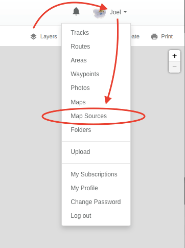
Step 1: Login to your account on GaiaGPS.com
Step 2: Click on your account name on the top right of the screen and select Map Sources
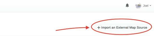
Step 3: Click on Import an External Map Source
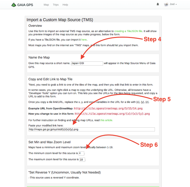
Step 4: In the Name the Map section – enter whatever name you want to name this map source (ie. Japan GSI );
Step 5: In the Copy and Edit Link to Map Tile section – copy and paste the following url:
http://maps.gsi.go.jp/xyz/std/{z}/{x}/{y}.png
Step 6: In the Set Min and Max Zoom Level section – enter the minimum value as 4 and the maximum value as 18
Step 7: Click Add this Map Source button
Step 8: Go back to the main Map section on GaiaGPS and the new map source will appear in your Layers dropdown and also on your map sources on your iOS or Android device, once it has synced with your account.


Footnote: For your reference – The Japanese Government’s web-based map browser for this map source is located here
Adding ESRI World Topo to GaiaGPS

ESRI World Topo used to be a default map source for Gaia but has since been removed. It is extremely useful as it provides good details (such as small creek lines etc) that are evened out on some of the other lower resolution topo maps. Best yet, it covers almost the entire globe.
If you don’t have access to it already, you can add it easily by following the steps listed above altering as per below:
Step 5: In the Copy and Edit Link to Map Tile section – copy and paste the following url:
http://server.arcgisonline.com/ArcGIS/rest/services/World_Topo_Map/MapServer/tile/{z}/{y}/{x}
Step 6: In the Set Min and Max Zoom Level section – enter the minimum value as 4 and the maximum value as 22
Footnote: For your reference – The ESRI web-based map browser for this map source is located here
Adding the NSW Government (SIX) Topographic Map

The NSW Government’s free map data is accessible easily with the below details entered into Gaia. The map itself can be useful, but generally, the topo data isn’t as detailed as what you may be able to get from Gaia’s inbuilt map sources.
Step 5: In the Copy and Edit Link to Map Tile section – copy and paste the following url:
http://maps.six.nsw.gov.au/arcgis/rest/services/public/NSW_Base_Map/MapServer/tile/{z}/{y}/{x}
Step 6: In the Set Min and Max Zoom Level section – enter the minimum value as 4 and the maximum value as 21
Footnote: For your reference – The NSW Government’s web-based map browser for this map source is located here
Nice post! Can I also add a recommendation for Backcountry Navigator for Android which includes many of these map sources by default, and also has the option to add custom map sources in a similar manner.
Joel, another great map layer in Gaia GPS you may want to check out is called “Open Topo”. It’s open source, it covers the entire world, has good shaded relief, has heights in meters, has probably the most current trail / road information of any map source, and shows some vegetation types (forest vs above timberline) and even some public versus private landownership in the United States. Have a look, and compare it to the maps of Japan that you have. You may will find that this built in map source serves your needs without doing any fancy shenanigans of importing other map sources. Having said that, thank you for explaining a procedure in Gaia GPS that I always wondered about doing it myself.
I’ll second that recommendation for the OpenTopoMap layer, it’s pretty good, ended up using it a lot this winter. I also started using Locusmap for Android this winter, which is by far the best I’ve seen so far. Along with OpenTopoMap has map sources available for the Linz Topo maps, Japan’s Topo maps, and many many others. It also has a shading overlay where you can shade by slope angle as it approaches 38 degrees getting red!
Hi guys, firstly, thank you for commenting.
I will agree that OpenTopo (https://opentopomap.org) is a very useful map source and it certainly looks pretty with it’s shaded relief. But I think if you compare it to some of the more high detailed country-specific topo maps, you might find that it lacks contour detail.
As an example, I’ll show you the summit of Kurodake, a peak in Hokkaido Japan:
Here is the Open Topo:
https://skidescent.com/wp-content/uploads/2017/12/Kurodake-OpenTopo.png
And here is the GSI Japan Topo:
https://skidescent.com/wp-content/uploads/2017/12/Kurodake-GSI.png
It’s quite obvious that the GSI data is of a higher quality. If you were relying on the OpenTopo data, it would look like the northern side of the mountain is steep but not sheer/cliffs but the GSI tells a different story. For reference here is a photo of the north side of Kurdodake peak:
https://skidescent.com/wp-content/uploads/2017/12/Kurodakenorthside.jpg
It’s also worth looking closer at the GSI data that shows small creek lines in contours etc that are skipped by the averaging out that is present in the OpenTopo data.
But repeating my first sentiment, OpenTopo does provide a useful source for info, especially if there isn’t a higher quality local map source available. If you’re a Gaia user, it’s recently been taken off the Gaia source list because it was overloading the OpenTopo server with usage. (Source: https://www.reddit.com/r/GaiaGPS/comments/7303fh/wheres_open_topo/ ).
Further to the reddit post, note the FAQ page for Open Topo states:
But, if you’re a Gaia user and you want OpenTopo back in your map sources, you can add it back using the above method and inserting the following data:
http://c.tile.opentopomap.org/{z}/{x}/{y}. pngZoom Levels 4-17
(remove the space before png in the url – I can’t post the url properly because it tries to show a picture)
I’m sure Backcountry Navigator is a great App but I haven’t used it much because I am a Gaia user and there is an opportunity cost to switching (routes saved in cloud, familiarity with the program etc). I’m glad to hear that it has a heat-map for slope angle, that’s a useful feature if you’re not too familiar with reading a topo and one that I’ve only seen readily available from Avanet/Mtnhub.
You should note that Gaia for Android is a different app to Gaia for iOS and the development of the Android app is a year (possibly several) behind the iOS version.
Cheers,
Joel